
|
| Current weather at Coffee Bluff: |
Wind:
SW at 4 mph G:13 | Max Wind:
25 at 3:41p | Temp:
93.3 | Heat Index:
109 | Hum:
61% | Dew Point:
77.8 | Baro:
29.74 → | Max:
93.4 | Min:
77.1 | Rainfall today:
0.00 | Time:
3:44p
|
Weather Information for SE GA / SE SC
Today is Sunday, August 2, 2026 ... Day 214 of the Year
|

ogeechgeemeatmarket.com
|
Pat's Forecast for SE GA / SE SC
Temperatures will warm to around 90 today and then upper 80s on Monday.
A Rain Period is Upon Us
There will be a good chance for thunderstorms today and tomorrow, dropping a bit Tuesday through Thursday, then increasing to moderate to good chances by the end of the week going into the upcoming weekend. Rain totals through this period could easily exceed 3 inches.
Tropical Weather: ... All Quiet in the Atlantic basin
The drought conditions have improved a bit over the past week with those periods of rain. (See Drought Maps).
Normal High for Today is 92 and Normal Low is 73
Astronomy Video ... June 7 ... A Tour of Globular Clusters of Stars
Astronomy Video ... July 7 ... My Review of the SvBony SV503 102mm Telescope
Weather Video ... August 1 ... Rain Coming in ... How Hot was July?
Sunday
Aug 2 | Daytime High: 90°
Overnight Low: 73°
Rain Chance: 90% | Mostly cloudy with a good chance for showers and thunderstorms. Some storms will generate periods of heavy rains. Highs will be in the lower 90s and overnight lows in the mid 70s
|
|---|
Monday
Aug 3 | Daytime High: 89°
Overnight Low: 73°
Rain Chance: 80% | Mostly cloudy with a good chance for showers and thunderstorms. Some storms will generate periods of heavy rains. Highs will be in the lower 90s and overnight lows in the mid 70s
|
|---|
Tuesday
Aug 4
| Daytime High: 92°
Overnight Low: 75°
Rain Chance: 60% | Partly cloudy with a moderate chance for showers and thunderstorms. Highs will be in the lower 90s and lows in the mid 70s
|
|---|
Wednesday, Aug 5
Daytime High: 93°
Overnight Low: 76°
Rain Chance: 40%
| Thursday, Aug 6
Daytime High: 93°
Overnight Low: 76°
Rain Chance: 60%
| Friday, Aug 7
Daytime High: 93°
Overnight Low: 75°
Rain Chance: 40%
| Saturday, Aug 8

Daytime High: 92°
Overnight Low: 75°
Rain Chance: 60%
| Sunday, Aug 9
Daytime High: 93°
Overnight Low: 75°
Rain Chance: 60%
|
See the FORECAST RAIN CHANCES/AMOUNTS ... FORECAST TEMPERATURES ... and the FORECAST CLOUDS & WINDS for your area
Beach Water Temperatures are around 87°F (30.6°C)
Weather Discussion:
A complete & comprehensive meteorological discussion is available from the National Weather Service, Charleston and from the NWS, Jacksonville, FL
Temperature & Precipitation Outlooks: 6-10 Days ...
8-14 Days
Pat's 6 Week Weather Outlook
WEEK 1
Aug 2-Aug 9
Slightly Above Normal
Normal High = 92 ... Low = 73
Precip: Above Normal
Normal: 1.54" per week)
|
WEEK 2
Aug 10-Aug 16
Slightly Above Normal
Normal High = 91 ... Low = 73
Precip: Around Normal
Normal: 1.54" per week)
| WEEK 3
Aug 17-Aug 23
Slightly Above Normal
Normal High = 90 ... Low = 72
Precip: Slightly Below Normal
Normal: 1.47" per week)
|
|
|
WEEK 4
Aug 24-Aug 30
Above Normal
Normal High = 90 ... Low = 72
Precip: Slightly Below Normal
Normal: 1.54" per week)
|
WEEK 5
Aug 31-Sep 6
Above Normal
Normal High = 89 ... Low = 71
Precip: Slightly Below Normal
Normal: 1.26" per week)
|
WEEK 6
Sep 7-Sep 13
Above Normal
Normal High = 88 ... Low = 70
Precip: Slightly Below Normal
Normal: 1.12" per week)
|
|
|
|
This is not a forecast but just an 'outlook'. Keep in mind, the 7 day period is the average of those days with some days above the values and other could be below the values. This is used to get a better idea as to what to expect (maybe).
|
|
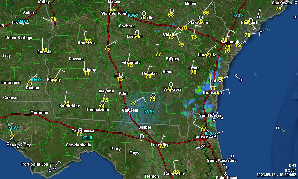
Radar Views
|
Doppler Radar Level 3 Data
From KCLX ... Grays, SC ... NWS, Charleston
|

|
... Click on Radar for Animation & More Products ...
|
Doppler Radar Level 3 Data
From KVAX ... Moody AFB, Valdosta, GA
|
|
... Click on Radar for Animation ...

|
Realtime Lightning Display
|
|
|
|
|

Looking for a hosting service for your web page? A2 Hosting would be a good choice
 Send our comments to Patrick Prokop ... patprokop49@gmail.com
Visitors to this page:
...
 Severe Weather Outlook


 Asbury Memorial Church ...


